Glacier melt close to record high

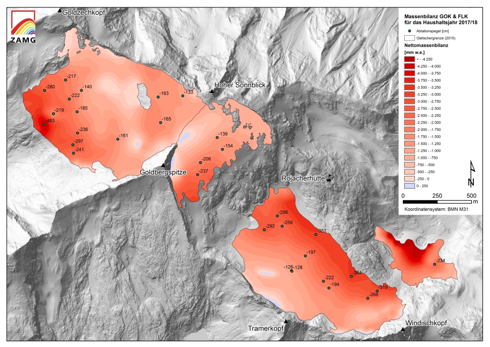
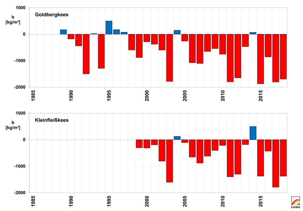
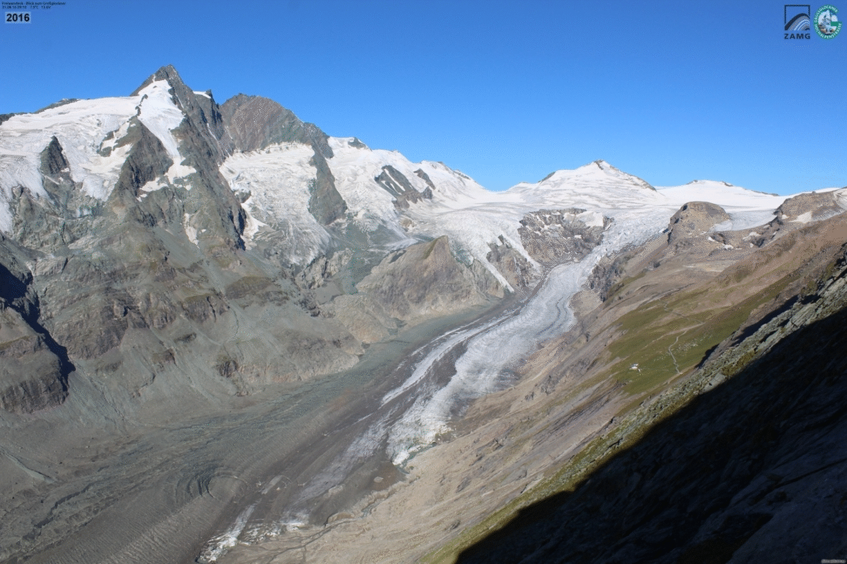
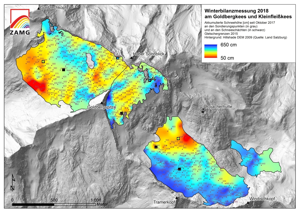
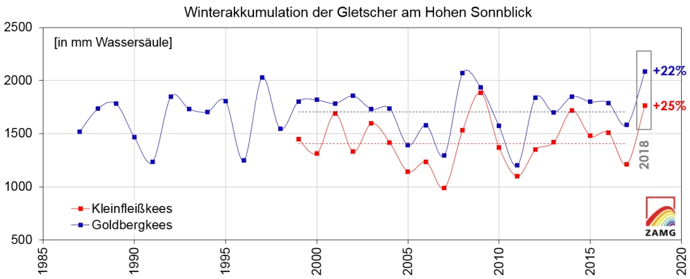
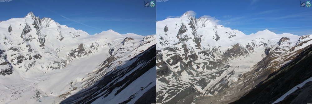
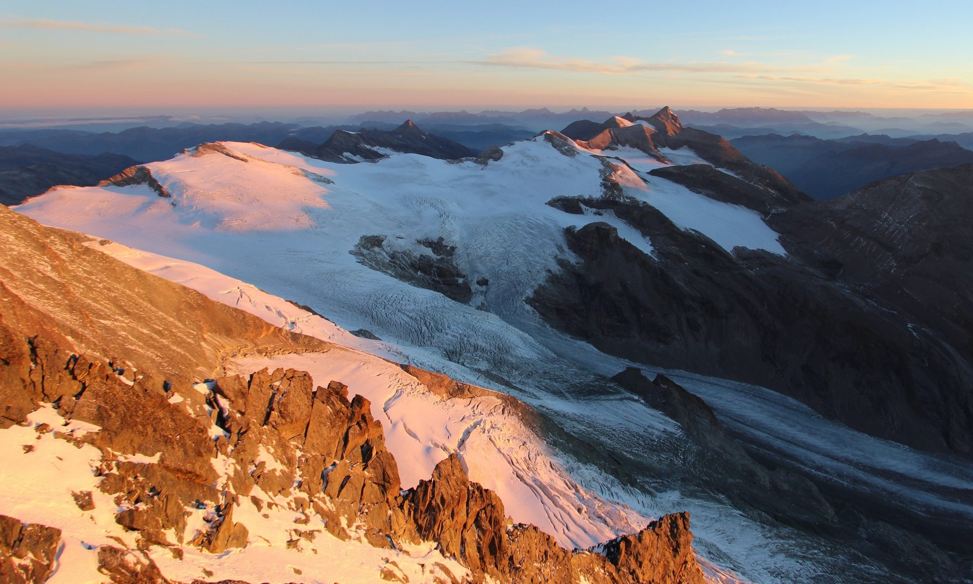
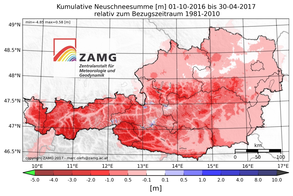
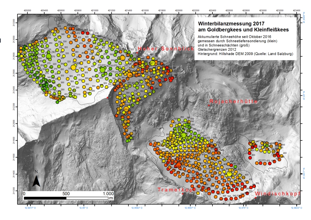
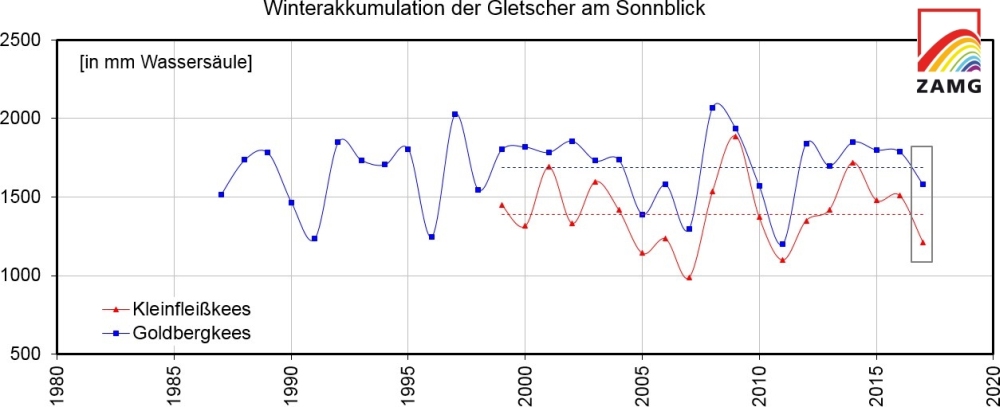
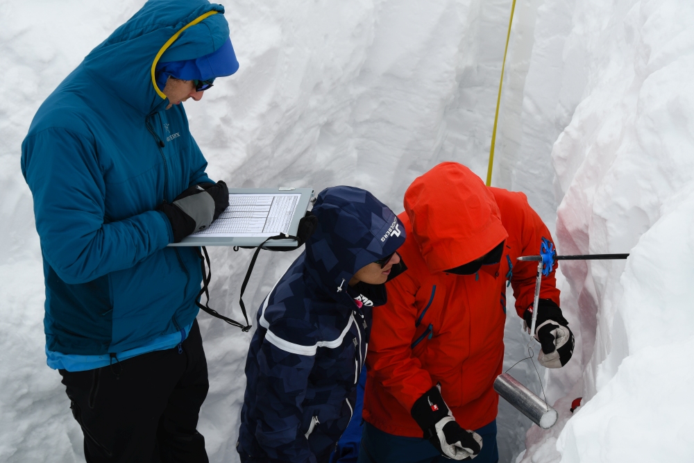
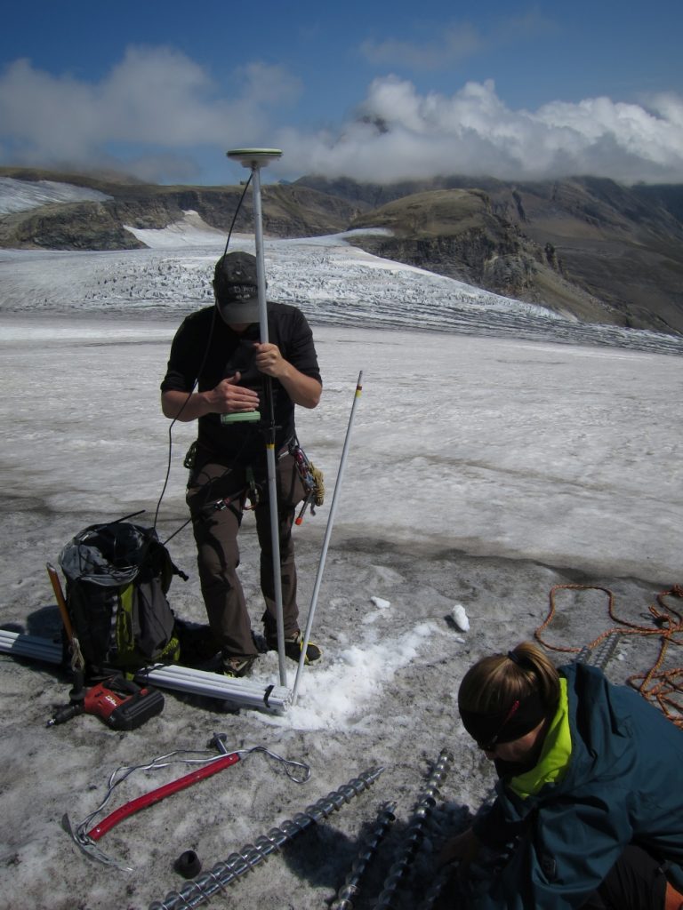
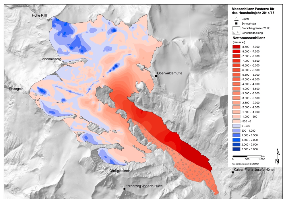
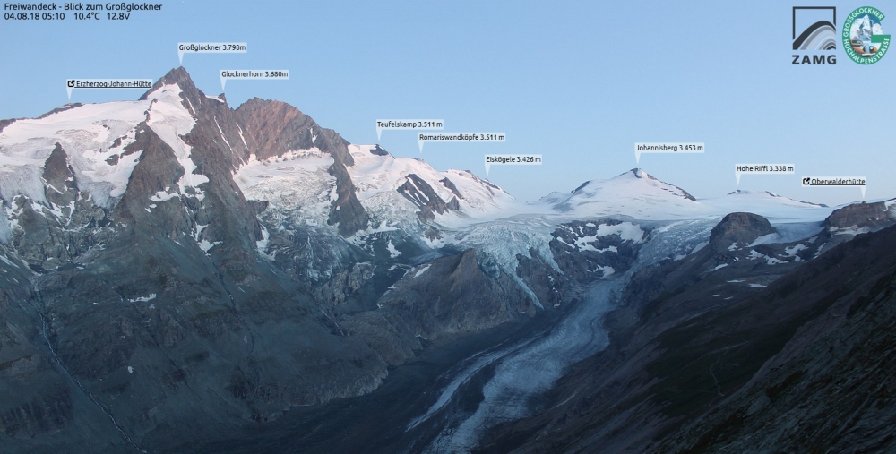
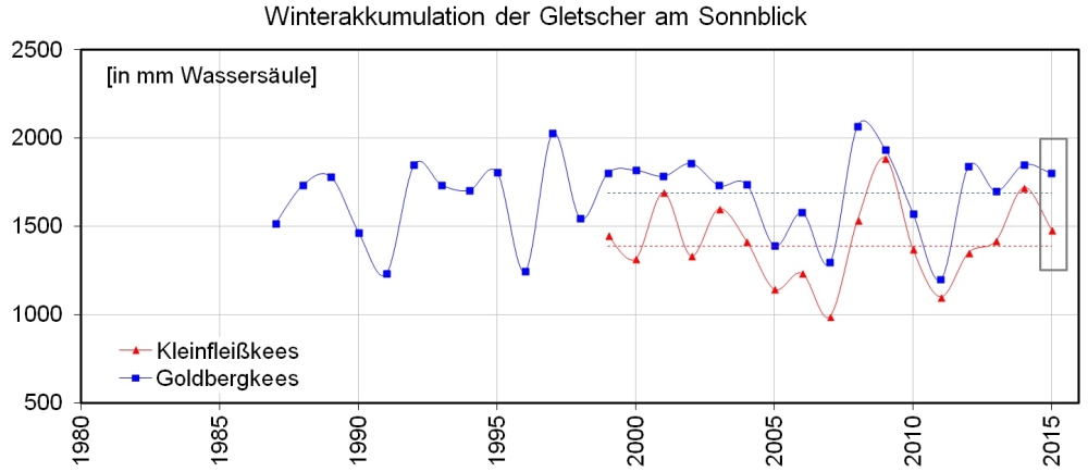
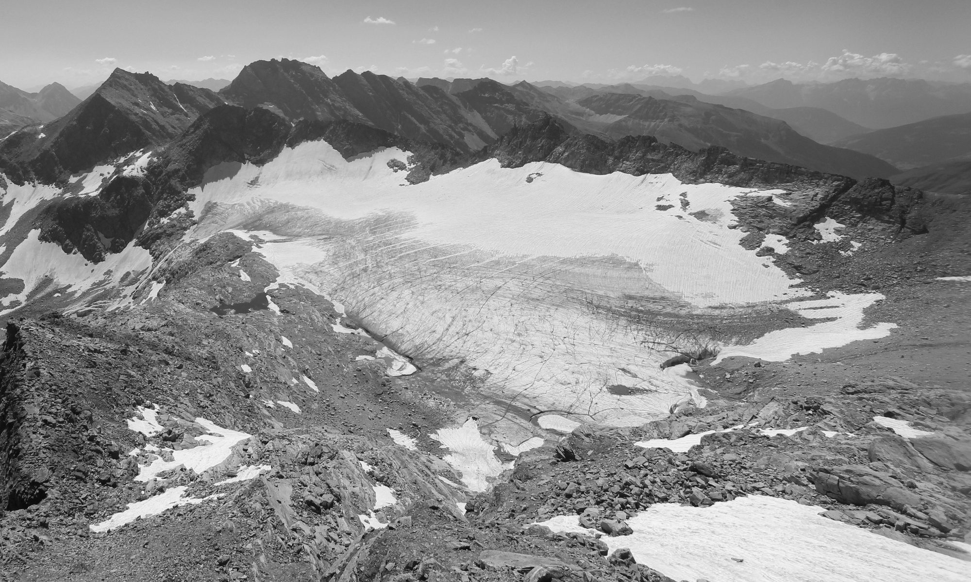
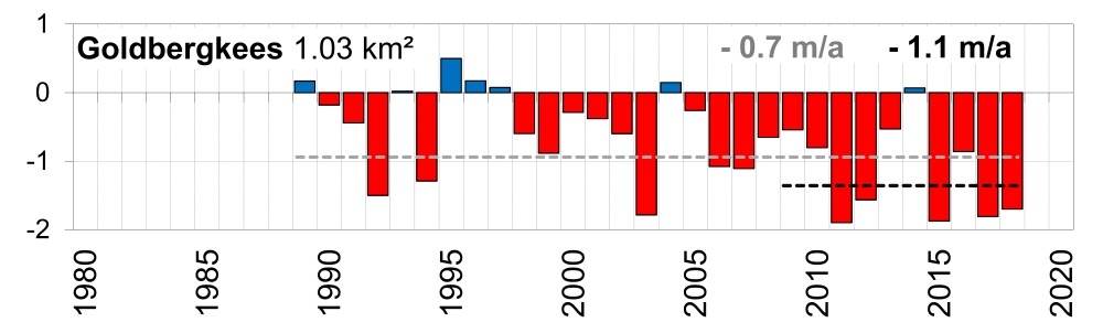
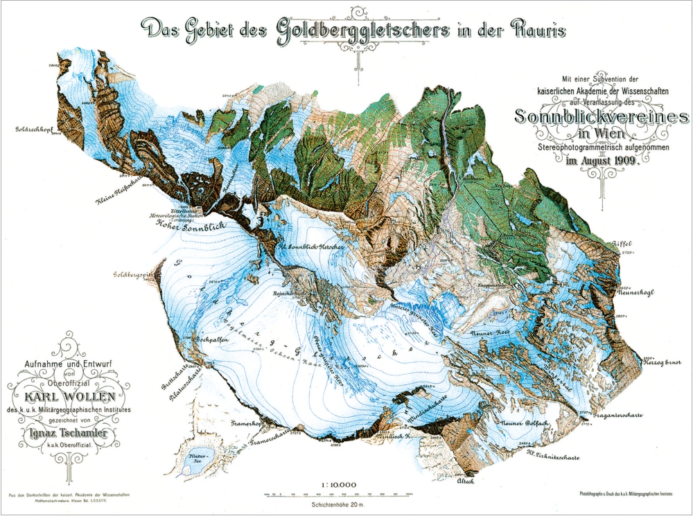
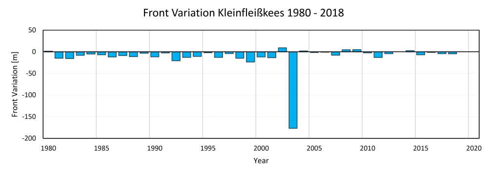
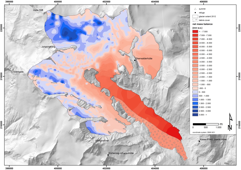
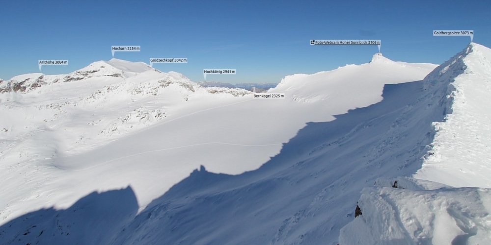
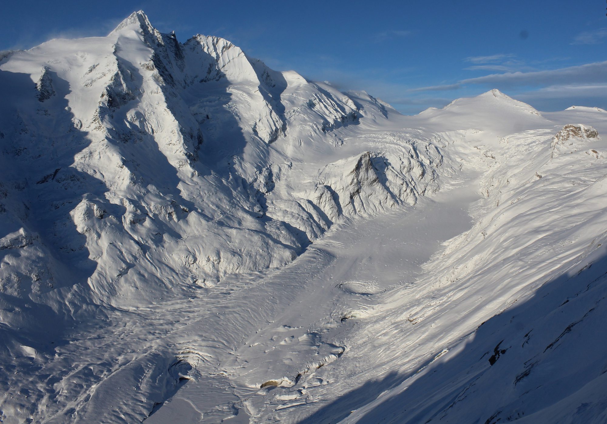
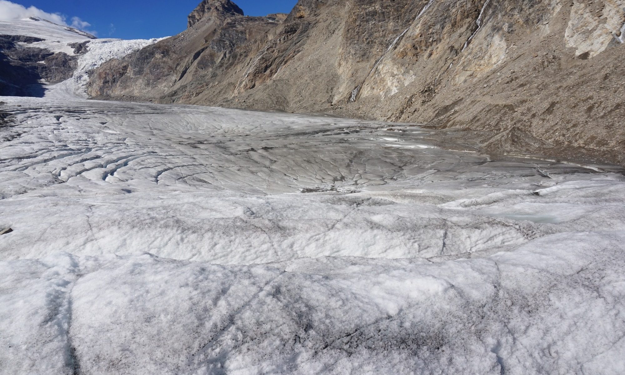
The dry and extreme warm summer months have severely eroded the glaciers in the Austrian Alps. Despite the above average snowpack in winter in the Hohe Tauern Mountains, Goldbergkees lost 1700 mm w.e. a-1 of mass and Kleinfleißkees 1400 mm w.e. a-1 of mass. That’s just slightly behind the record melting of 2003, 2011, 2015 and 2017. Other glaciers in the northern Austrian Alps and in the West of Austria even suffered more than the glaciers in the Hohe Tauern. The reason for this is the lack of above average snowpack in winter compared to the Sonnblick glaciers. The glacier tongue of Pasterze continues to disintegrate. This part of the glacier, the area below the icefall, the debris free glacier had a mean loss of 6.2 m of ice thickness with a maximum at the glacier terminus up to 10 m.

https://youtube.com/watch?v=JaqAzWHW3n0

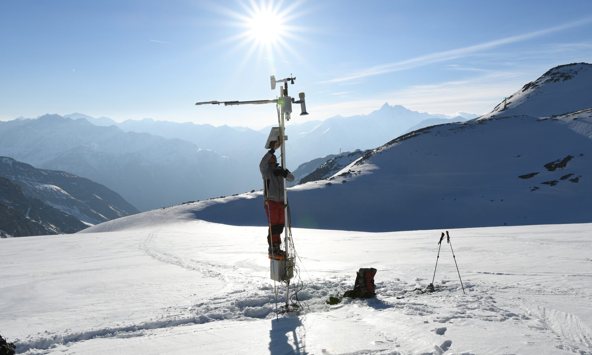
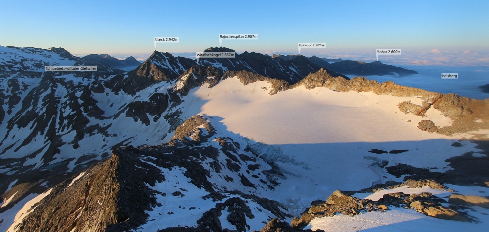
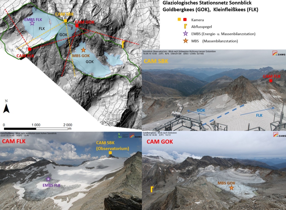
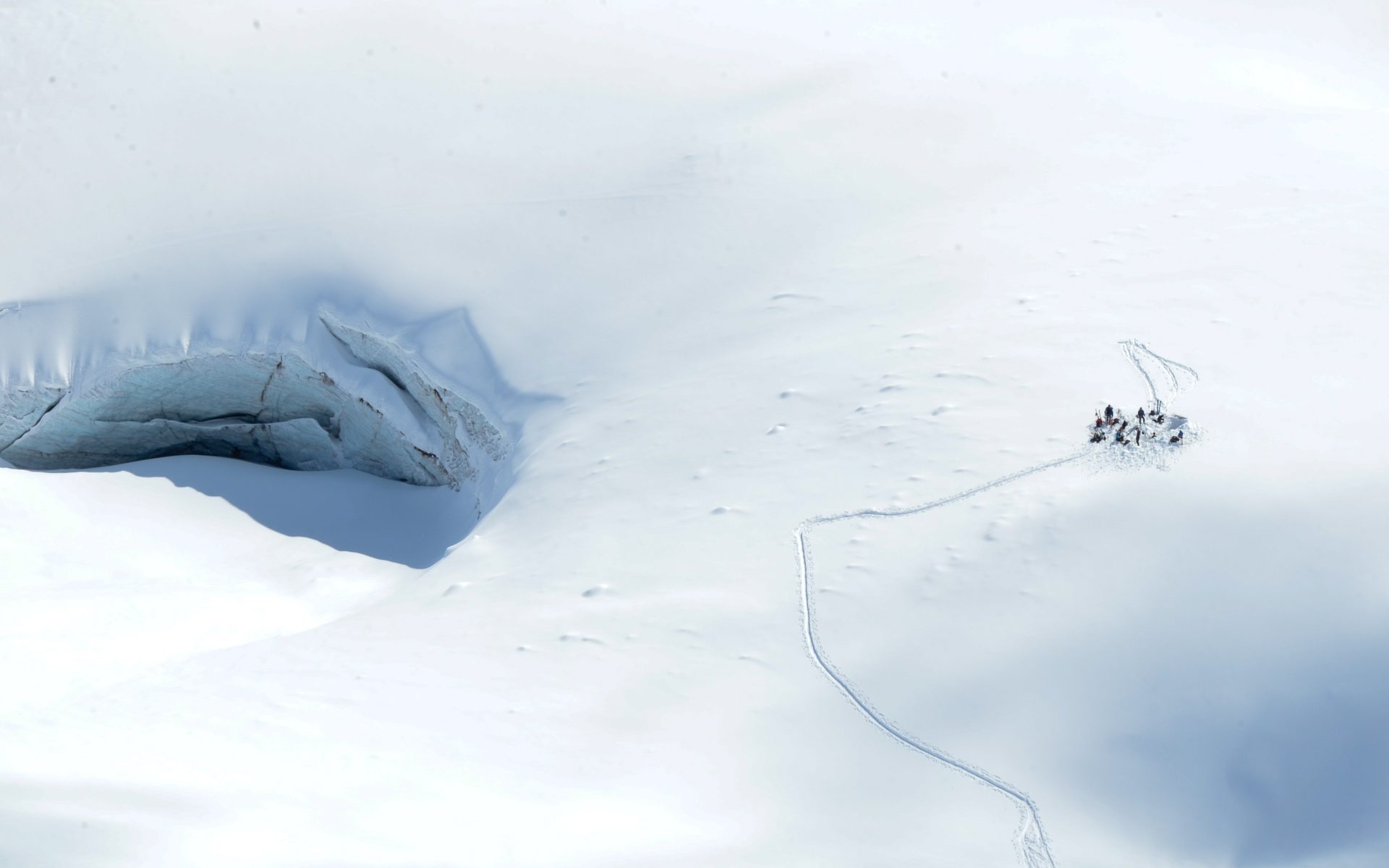
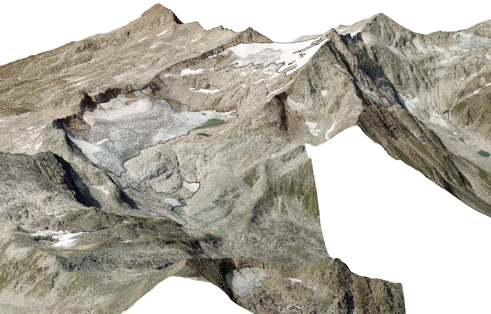
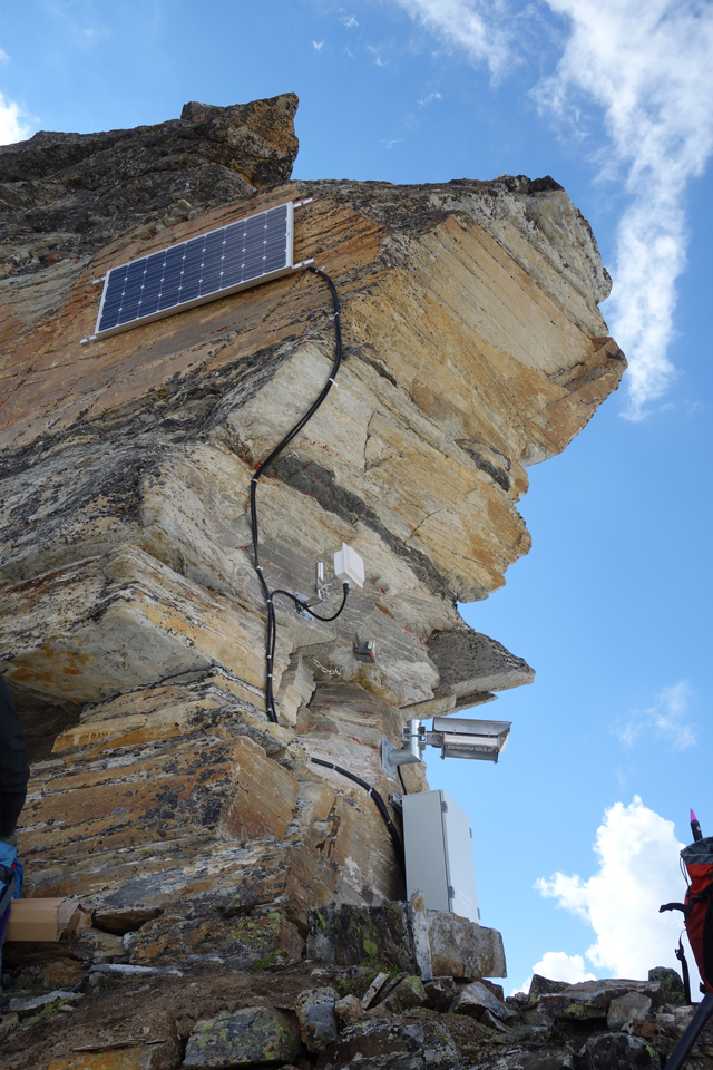
Time lapse of melting snow from webcam Goldbergkees.

Annual mass balance for Kleinfleißkees (left) and Goldbergkees (right). The circles represents the ablation stake network with the annual loss in cm.
Time series of annual mass balance for Goldbergkees and Kleinfleißkees.
Time lapse from the last three year (2016, 2017 and 2018) of Pasterze.

Winter 2017/18: Largest amount of snow for Sonnblick glaciers over the last 20 years

Kleinfleißkees and Goldbergkees got 25 % more snow than in an average winter. For determination of snow depth, 560 measurements with snow probes were carried out. Additionally eight snow pits were dug for density and temperature measurements of the snowpack. The mean snow depth for Goldbergkees is 460 cm and for Kleinfleißkees it is 390 cm. Referring to density and snow depth measurements, the winter mass balance of Goldbergkees is 2080 mm w.e. a-1, that’s 22 % above average and for Kleinfleißkees it is 1760 mm w.e. a-1. That is 25 % more than in an average winter.
The summers are crucial for Austria’s glaciers. The extremely warm April has compensated the above-average snow cover. For early June, the snow depths are even below the average. For long-term development of glaciers in Austria, the weather conditions in summer are more important than in winter. Occasional occurred cold surges in summer brings snow cover on glaciers. Because a fresh, very with snow cover reflects almost all solar radiation. This can protect a glacier up to a week before melting. However, a glacier without fresh snow cover is much darker, therefore absorbs a lot of solar radiation an can lose up to 10 cm of ice thickness in one day.

Digging a snow pit (photo: V. Alge).
Accumulated snow depth between October 2017 and end of April 2018 for Kleinfleißkees (left) and Goldbergkees (right).
Time series of winter mass balance Kleinfleißkees and Goldbergkees.
View at Pasterze from webcam location Freiwandeck. Comparison between an image form late April (left) and late May (right). End of April, at the glacier snout were 90 cm of snow measured. End of May, at the same position no snow remained.

Glaciological station network Pasterze

In cooperation with foto-webcam.eu, University of Graz, Großglockner Hochalpenstraße AG and TGM, a glaciological station network was established. In total 5 cameras, one automatic weather station (EMBS PAS) and one mass balance station (MBS PAS) are in operation. The locations of the cameras are Freiwandeck (FWE), Fuscherkarkopf (FKK), kleiner Burgstall with two cameras (BUR) and (PAS) and Großglockner (GLO). This is by the way the highest situated camera in Austria with an altitude of 3750 m a.s.l.. On the glacier surface there is a automatic weather station situated on the glacier tongue and a mass balance station in the upper part of the glacier.

Map of the glaciological station network of Pasterze with location of the 5 cameras, the automatic weather station and the mass balance station. The dashed lines are the visual axis of each camera. Also marked is the boundary of the catchment and the area of Pasterze.
View of the cameras (BUR top left, FKK top right, GLO centre left, FWE centre right and PAS bottom left).

The major aims are to observe the level of snow coverage, calculate flow velocity and to document the glacier retreat.

Mass balance station (MBS PAS) (left) located in the upper part of Pasterze and the automatic weather station (EMBS PAS) situated on the tongue of Pasterze.

The EMBS PAS measures air temperature at two different levels, humidity, wind speed, wind direction, snow depth and radiation balance between incoming short wave and long wave versus surface reflected short wave, outgoing long wave radiation and ablation of ice with a pressure sensor. MBS PAS record snow depth and ablation of ice.

Winter 2016/17: 10 % less mass of snow than average

Less mass of snow, but average snow depth. Due to snowfall events in April, the relative fresh snow was not packed than normal in May. Therefore, snow depth is on average but the snow density is lower. This results in 1570 mm w.e. a-1 for Goldbergkees and 1210 mm w.e a-1 for Kleinfleißkees or 10 % less masses of snow for the winter 2016/17 than on average.
The snowpackmodel SNOWGRID from ZAMG shows that the average snowpack of Sonnblick glaciers are not representative for major areas of Austria. The meteorological winter (December, January and February) was very dry and the precipitation in April was rain up to low mountain range due to warm weather conditions. As a result, the cumulated sums of fresh snow for major parts of Austria were well below average for the hydrological winter (October 2016 – April 2017).

Cumulated sums of fresh snow for the hydrological winter 2016/17 for Austria (snowpackmodel SNOWGRID from ZAMG).
Snow depth measurements for Goldbergkees and Kleinfleißkees. Big circles are snow pits and small circles are measurements with probes. Green presents low snow depth and red high snow depth.
Time series for winter mass balance of Goldbergkees and Kleinfleiskees.
Snow density measurement in a snow pit (photo: G. Weyss).

New webcam on Goldbergkees

The camera is located on the ridge between the alpine hut Rojacherhütte and the summit of Hohen Sonnblick at 2932 m a.s.l.. The direction of view is southeast with skiing area Mölltaler Gletscher far left on the image, the Goldbergkees in the centre and the mountain pass Iselsberg rightmost. The camera was installed 2nd August 2016. The engaged camera is a Canon EOS1200D. For power supply, a solar panel is used and the power is stored in a accumulator. The glaciological station network Sonnblick contains beside webcam Goldbergkees also webcam Kleinfleißkees, webcam Sonnblick Observatorium, automatic weather station Kleinfleißkees, mass balance station Goldbergkees and gauging station Huettwinklache.

Current image from webcam Goldbergkees.
Image from webcam Goldbergkees with annotations of the surrounding.
Alignment of the camera (photo: G. Keuschnig).
Complete camera system with solar panel and camera in the protection casing (photo: G. Keuschnig).
Map of glaciological station network Sonnblick with glacier boundary of Goldbergkees (GOK) and Kleinfleißkees (FLK) (top) and images of the webcams Kleinfleißkees (CAM FLK), Goldbergkees (CAM GOK) and Sonnblick Observatorium (CAM SBK) (bottom). Also marked in the map is the automatic weather station (EMBS FLK) at Kleinfleißkees, mass balance station (MBS GOK) Goldbergkees and gauging station Huettwinklache beside the localisation of the webcams.

Massive glacier melt in 2015

After a pleasant winter with 5 % more snow accumulation than average, the second warmest summer in history of temperature measurements and the driest summer since 1911 in Austria, melting rates were near record level from 2003. At the glacier terminus of Pasterze, the thickness of ice decreases up to 10 m, between autumn 2014 and autumn 2015. Overall, the annual mass balance for Pasterze is -1.4 m w.e. a-1. For the glaciers at Hoher Sonnblick, the annual mass balance for Kleinfleißkees is -1.4 m w.e. a-1 and for Goldbergkees -1.9 m w.e. a-1.

https://youtube.com/watch?v=TXC0Y56wG3w

Evolution of the terminus of Pasterze between 2011 and 2015.

Drilling and DGPS survey of a ablationstake in the upper part of Pasterze (photo: R. Koch).
Annual mass balance [mm w.e. a-1] of Pasterze 2014/2015.

New webcam on Pasterze at Freiwandeck

This camera is funded by Großglockern Hochalpenstraße AG. The camera is located at Freiwandeck (2755 m a.s.l.). The direction of view is west to Großglockner and Pasterze with alpine hut Erzherzog-Johann-Hütte leftmost and alpine hut Oberwalderhütte rightmost. The camera was mounted 5th October 2015. The engaged camera is a Canon EOS1200D. For power supply, a solar panel is used and the power is stored in a accumulator.

Current image from webcam Freiwandeck.
Image from webcam Freiwandeck with annotations of the surrounding.
Installation of the solar battery (photo: G. Keuschnig).
Complete setup of webcam Freiwandeck.

Snow accumulation in winter 2014/15 slightly above average

Due to more than 700 measurements of snow depth and 9 snow pits, where density and temperature of the snowpack was measured, the winter mass balance for Goldbergkees and Kleinfleißkees is 5 % above the average. Particularly for Goldbergkees a mean snow depth of 450 cm (1800 mm w.e.) and for Kleinfleißkees 390 cm (1400 mm w.e.).

Winter balance measurements 2014/15 for Goldbergkees and Kleinfleißkees. Accumulated snow depth between October 2014 and 30th April 2015. Snow depth measurements in blue and snow pits in black.
Time series of winter mass balance [mm w.e.] for Goldbergkees (blue) and Kleinfleißkees (red).
Drilling a snow core for density measurements (photo: B. Hynek).

Goldbergkees – History

The Goldbergkees (formally known as Vogelmaier – Ochsenkarkees), situated in the Austrian alps (Hohe Tauern), is now divided in three parts. The upper part is near the summit of Hoher Sonnblick. The part in the middle is largest part of the glacier. The lowest part of the glacier is also the smallest. Overall, the total area of Goldbergkees is 1.03 km² (2015). The glacier covers an altitudinal range from 2400 to 3050 m a.s.l., is exposed mainly to N & E and draining via Hüttwinklache into the Salzach river.

The three parts of Goldbergkees (aerial image from 2015, digital elevation model from 2009).

Mass balance measurements started 1988/89. The mean annual mass loss of the entire investigation period is -0.7 m w.e. a-1 and -1.1 m w.e. a-1 for the last decade.

Time series of mass balance measurements of Goldbergkees [m. w.e. a -1].

Between 1871 and 2015, the glacier lost 73 % of the glaciated area and 60 % of ice thickness. The following table shows the evolution of glacier area and mean ice thickness of Goldbergkees from 1871 – 2015 in different time steps.

Evolution of Goldbergkees (glacier area [km²] and mean ice thickness [m]).
Time series of images from 1829, 1983, 2003 and 2015. The image of 1829 is a watercolor painting of Thomas Ender. The images 1983, 2003 (photos: R. Böhm) and 2015 (photo: S. Reisenhofer) were taken from photo point Herzog Ernst.
Historic map of Goldbergkees from 1909. This was the first time that terrestrial photogrammetry were used to map a glaciated region (source: A. Hübl, 1912).

Kleinfleißkees – History

The Kleinfleißkees, with a total area of 0.79 km² (2015), is situated in the Hohe Tauern as part of the Austrian alps. The glacier covers an altitudinal range from 2700 to 3050 m a.s.l., is exposed to W and draining into the Möll river. Between 1850 and 2015, Kleinfleißkees lost 59 % of the glaciated area. Mass balance measurements started 1998/99. The mean annual mass loss of the entire investigation period is 0.7 m w.e. a-1 and 0.8 m w.e. a-1 for the last decade. Only two years (2004 and 2014) have a positive mean annual mass balance. Mean values (1981 – 2010) of annual temperature and precipitation at the nearby station at Sonnblick (3105 m a.s.l.) are -5.0 °C and 2114 mm.

Seasonal Mass Changes of Kleinfleißkees.

In autumn 2002 a ice fall event occurred. The glacier tongue break off over a step in the bedrock. In the last years, the glacier retreated above the steep slope. The mean retreat of the front variation between 1980 – 2018 is 11 m. In the last decade, the mean retreat is 3 m.

Ice fall event in autumn 2002 (photo. R. Böhm).
Time series of front variation of Kleinfleißkees.

Pasterze – History

Austria’s most popular glacier at the foot of Großglockner – Austria’s highest mountain. Pasterze is the largest part of a combined mountain glacier system in the Austrian Alps (Hohe Tauern) with several accumulation basins and valley glaciers. The total area of Pasterze Glacier is 16.3 km² (2012) and covers and altitudinal range from 2100 to 3500 m a.s.l.. The 5 km long distinctive glacier tongue is partly covered by a 5-20 cm thick debris layer, exposed to SE and draining into the Möll river. Geophysical surveys in 1998 revealed a maximum ice thickness of 320 m and a mean ice thickness of 64 m. Mass balance measurements were carried out between 1979/80 and 1996/97 and resumed in 2004/05. The mean annual mass loss of the entire investigation period is -0.9 m w.e. a-1 and -1.1 m w.e. a-1 for the last decade. Geodetic mass balances show a mean mass loss of 0.56 m w.e. a-1 between 1969 and 1998 and 1.21 m w.e. a-1 between 1998 and 2012.

Time series of mass balance measurements of Pasterze [m. w.e. a-1]
Net mass balance [mm w.e.] 2015/16 of Pasterze and Wasserfallwinkelkees
Mean annual decrease of ice thickness [m/a] of Pasterze (left) 1969 – 1998 (right) 1998 – 2012

New webcam on Kleinfleißkees

The camera is situated on a ridge between the mountains Goldberspitze and Roten Mann at 2970 m a.s.l.. The direction of view is northeast with Goldbergspitze at the far right. In the center of the image is Kleinfleißkees with Hohen Sonnblick. Leftmost on the image is the mountain Arlthöhe. The camera was mounted 17th July 2014 and so the first webcam in operation for our automatic glacier measurement system. The engaged camera is a Canon EOS1100D. For power supply a solar panel is used and the power is stored in a accumulator.

Current image from webcam Kleinfleißkees.
Image from webcam Kleinfleißkees with annotation of the summits.
camera without protection casing (photo: G. Keuschnig).